
Mastering the Woods: How to Use Waypoints to Scout Smarter
Scouting with Precision: Why Waypoints Matter
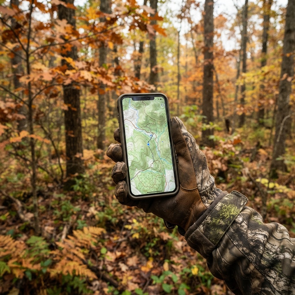
Every seasoned hunter knows that the difference between a filled tag and a long, quiet day in the stand often comes down to preparation. If you walk into the woods blind—literally—you are already at a disadvantage. Modern technology has provided us with an incredible edge, and at the Buckeye Hunter Hub, we believe that utilizing is the single most effective way to turn a chaotic scouting trip into a calculated strategy. By marking waypoints for your stands, blinds, and trail cameras, you create a visual narrative of your hunting property that helps you understand deer behavior, wind patterns, and access routes.
Getting Started with Buckeye Hunter Hub Mapping
The goal of a digital waypoint system is to replace the mental map in your head with a high-definition, interactive reality. Whether you are hunting a small private woodlot or thousands of acres of public land, the process remains the same: you identify a feature, tag it, and analyze how it fits into the broader picture of your hunting area.
Step 1: Navigating to the Map
Log in to your Buckeye Hunter Hub account and navigate to our . Ensure your location settings are enabled so the interface can drop you directly into the region you are scouting. Once the satellite imagery loads, spend a few minutes familiarizing yourself with the terrain. Look for obvious funnels, ridges, and water sources.
Step 2: Dropping Your First Waypoint
To mark a stand or blind, identify the exact coordinates on the map where you intend to sit. Click the 'Add Waypoint' button. A drop-down menu will appear, allowing you to categorize your marker. Choose 'Stand' or 'Blind' and name it accordingly—for example, 'Oak Flat Ladder' or 'Creek Bottom Ground Blind.'
Step 3: Integrating Trail Camera Data
Trail cameras are the eyes of the forest, but they are useless if you can't remember where they are or what they’ve captured. When placing a camera, mark a waypoint on your map. In the notes section of that waypoint, record the date of deployment and the camera's ID number. This allows you to track which cameras are providing the most intel. When you check your cameras, update the note with a quick summary of activity, such as 'buck activity high' or 'no deer movement.'
Analyzing Data for Smarter Scouting
Washington · E-Tag State

Washington Harvest Tags
E-check means you supply the tag. Printed with the exact fields Washington requires.
3-pack $19.95
Once you have your waypoints set, the real magic happens. By looking at the placement of your stands in relation to your trail cameras, you can start to see patterns. Are the bucks consistently moving past the 'Oak Flat' stand during the evening hours? Does your camera at the 'Creek Crossing' only capture activity during rain events?
This is where you should cross-reference your findings with the . By observing when the most activity happens at your marked locations and comparing that to our movement predictions, you can begin to understand as it pertains specifically to your land. If you notice a pattern where movement drops off, you might realize your access route is causing too much disturbance. Use your map to draw a line from your parking area to your stand; if that line cuts through a bedding area, move your waypoint to an entry path that provides more stealth.
Managing Your Hunting Season
Raise a safe, confident young hunter.
Guide your kids ages 5–17 through interactive hunting safety missions, real decision drills, and earned trophies — all from one free parent account.




As the season progresses, your map becomes a living logbook. You don't just mark where you are; you mark where you want to be. If the wind changes, your map shows you exactly which alternate stands are available to account for the breeze.
For those who hunt multiple species, you can easily toggle between layers to keep your data organized. If you are preparing for waterfowl season, you might use your in conjunction with your map to ensure you have the best setup for the specific wind direction at your local marsh. Always verify your gear and plans against your to ensure you are compliant with local regulations regarding baiting or permanent stand placement.
Staying Organized for Success
Consistency is the key to harvesting mature game. By maintaining your waypoints, you eliminate the frantic 'where should I go today?' morning routine. You arrive at the woods knowing exactly where the wind is in your favor, which camera has been the most active, and which stand offers the best chance of interception.
If you ever feel like your scouting strategy needs a fresh perspective, head over to for more deep dives into advanced tactics. Remember, technology is not a substitute for woodsmanship—it is a tool that amplifies it. By capturing data, identifying patterns, and strategically placing your stands, you are doing more than just hunting; you are managing your environment and setting yourself up for success long before you ever zip up your boots.
Free hunting map, zones & 50-state resources
Save your spots, share zones with your group, and get deer & waterfowl movement forecasts — free.
Latest from the Community




Everything you need to hunt smarter — free
Buckeye Hunter Hub is a free, nationwide platform. Create an account and unlock the full toolkit:
Free Interactive Hunting Map
Mark stands, cameras, and sign. Draw hunting zones with public land & county overlays across all 50 states.
Zones with Group Sharing
Share zones with your hunting group, split property into sections, assign stands, and check in — all in one place.
50 States of Hunting Resources
Season dates, license links, and DNR regulations for every state, kept current so you never miss an opener.
Deer Movement Forecast
Data-driven daily movement predictions using wind, moon, and pressure — know when to sit before you go.
Waterfowl Movement & Tools
Flight-potential forecasts, migration numbers, decoy spread planner, and a full species field guide.
Shop This

StopBox Pro Ward | Wall-Mounted
$179.00$199.99

StopBox Pro Compact
$159.00$179.99

Streamline Supper Trout Heritage Tee
$23.41

Buckeye Hunter Hub Tee — Map It. Hunt It.
$23.41
E-Tag States

Harvest Tags
E-check means you supply the tag. Printed with the exact fields your state requires.
3-pack $19.95